
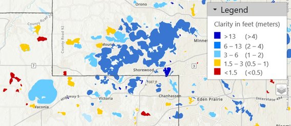
An embarrassment of riches: With more than 12,000 lakes, Minnesota has many more lakes than can be monitored by conventional ground-based sampling, but satellite remote sensing can do this. The figure shows a Landsat classification of water clarity in 2021 of lakes in Hennepin and Carver Counties. See Metrics – Lake Clarity page for details.
Protecting the quality of our lakes and rivers is an important societal goal, but because of human resource and financial limitations, only a small fraction of these resources can be monitored by ground-based methods. Satellite imagery can measure key water quality metrics, such as chlorophyll, turbidity, dissolved organic matter, and water clarity (Secchi depth), on virtually all lakes at low cost, greatly expanding the information available from ground-based monitoring.